KoreaClear.

KoreaClear · Achasan · Gwangjin · Seoul

Achasan: choose your trail

A shorter trail past fortress remains, or a ridge hike linking two mountains. Choose the route that fits your day.

Difficulty · KoreaClear criteria

Easy

Level terrain: up to 30 min

Moderate

Level terrain: over 30–90 min; most short mountain trails

Challenging

Level terrain: over 90 min; mountain routes ≥1.5 km and ≥60 min

Rating systems differ between pages. An official grade follows the operator’s own scale, so an “easy” route can still take over three hours. Compare routes by walking time and distance as well. Getting to and from stations is described separately in each route.

A. Achasan Fortress Trail

Follow a short mountain trail past Achasan Fortress to Nakta Pass, with a glimpse of Seoul’s historic fortress remains.

Difficulty
Moderate
Walking time
About 50 min
Distance
0.8 km
Food & water
Water & snacks
NAVER trail & elevation ↗

Select Achasan Fortress Trail on NAVER to view its elevation.

Walking time covers the marked trail only. Allow extra time for station access, breaks, descent and the journey back.

Walking order

On smaller screens, scroll sideways

  1. 1Near Walkerhill Apartments

    워커힐아파트

    Start
  2. 2Achasan Fortress

    아차산성

  3. 3Nakta Pass

    낙타고개

    Finish

Getting to the start

The official start is near Walkerhill Apartments. Open the start map to plan your approach. This route does not start at Meeting Plaza.

Start on NAVER Map ↗

Getting back

This section ends at Nakta Pass. The 50 minutes exclude your descent and return journey; plan these before setting out.

Know before you go

Check current booking conditions for the fortress interior; follow closure signs. ↗
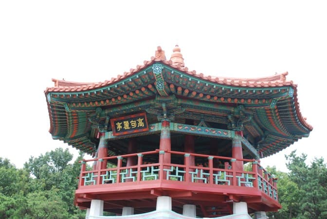
B. Achasan–Yongmasan Ridge Hike

Walk past Goguryeojeong Pavilion, Sunrise Plaza and Achasan’s fort sites towards Yongmasan’s summit—a longer hike linking two mountains.

Goguryeojeong pavilion with red pillars, painted eaves and its 高句麗亭 sign
고구려정 · 2009

Goguryeojeong · photographed 2009-08-08 (source date). Not confirmation of current appearance or access.

Difficulty
Challenging
Walking time
About 2 hr 10 min
Distance
3.6 km
Food & water
Water & snacks

Walking time covers the marked trail only. Allow extra time for station access, breaks, descent and the journey back.

Walking order

On smaller screens, scroll sideways

  1. 1Achasan Management Office

    아차산관리사무소

    Start
  2. 2Nakta Pass

    낙타고개

  3. 3Goguryeojeong Pavilion

    고구려정

  4. 4Sunrise Plaza

    해맞이광장

  5. 5Achasan fort sites

    아차산 보루군

  6. 6Yongmasan summit

    용마산 정상

    Finish

Getting to the start

From Meeting Plaza, head to Achasan Management Office. The official 3.6 km section starts at the office.

Start on NAVER Map ↗

Getting back

The official map calls this “Achasan Summit Trail”, but it ends on Yongmasan. The 130 minutes exclude the descent from that summit.

Know before you go

Wear shoes with grip. In rain or ice, check local closures and trail conditions.

Seoul Trail Route 5 also crosses Achasan

Seoul Trail Route 5 runs 4.6 km from the Kkalttakgogae Pass rest area on Yongmasan along the Achasan ridge to Gwangnaru Station (official rating: medium, about 2 hr 10 min). It is a different path from the two trails above.

See Seoul Trail Route 5 →